Bering Sea
Bering Sea
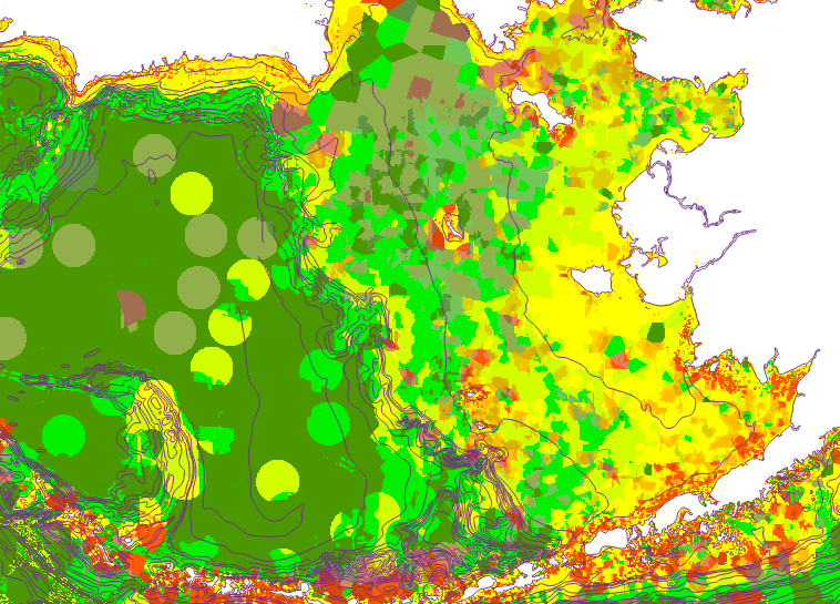
Under project work for future regulation of global deep-sea trawling, methods for map-interpolation of seabed characteristics have been extended. For statistical correctness, the mapping and analysis is done in equal-area projections, giving unbiased results over the latitude gradients of large areas. A fusion of Inverse Distance Weighted interpolation and Random Forest classification solves the problem of local versus regional map gridding for large areas having varying data densities. The IDW process allows proper mapping of actual local, perhaps unexpected materials. The RF process fills in areas far from actual data, with the regionally expectable results. The IDW method is a modified one, appropriate for the coastal zonation, directional biases in the data, and water depth variations. Full estimation of the map uncertainties is also carried out.
Graphics: The Bering Sea is an extremely important economic area for the USA in its fisheries, and these mappings will help plan for economic sustainability. The figure shows Folk seafloor sediment texture codes for the region based on the combined IDW-RF mapping, computed and rendered in Alaska Albers Equal Area Projection. Click HERE for legend and HERE for the corresponding uncertainty mapping.
The mapping depicts the zonation and patchiness of the seabed conditions. The IDW method rendered features like the Yukon prodelta correctly, which the RF method did not reproduce. The sandy spots marked on the abyssal plain are probably from scattered ice-rafted materials, or turbidites.
Similar mappings have been made for many areas of the globe, and can be computed to specification for areas with sufficient data.